
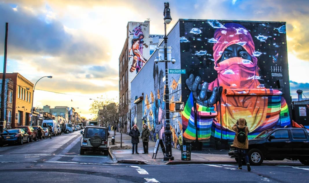

A Local Guide in Bushwick has to explain more than murals, bars, and the L train. Bushwick keeps changing because transit access, aging housing, former industrial land, new construction, immigrant business corridors, nightlife, and public investment all collide within a relatively compact part of Brooklyn. The changes are real, but they do not arrive evenly or follow one neat timeline.
This guide is grounded in city planning records, Community Board 4 material, and current MTA information rather than invented firsthand credentials. A Local Guide in Bushwick works best when it reads the neighborhood block by block, because the Bushwick Avenue experience can be markedly different from Broadway, Wyckoff Avenue, or the streets around Jefferson Street.
| # | What Drives the Change | Where You Notice It | What It Means Day to Day |
|---|---|---|---|
| 1 | Transit connections | L, J, M and Z corridors | Some blocks attract investment faster than others |
| 2 | Old housing stock | Bushwick Avenue and side streets | Renovation can quickly change rents and occupancy |
| 3 | Zoning and housing policy | Former manufacturing parcels | New residential buildings appear beside industrial uses |
| 4 | Small-site redevelopment | Mixed residential-industrial blocks | Change can happen one lot at a time |
| 5 | Arts, nightlife and retail | Jefferson Street and surrounding blocks | Storefront identity changes faster than the housing stock |
| 6 | Longtime communities | Knickerbocker, Myrtle and Broadway corridors | New businesses coexist with older institutions |
| 7 | Uneven transit access | Western and eastern Bushwick | A few extra walking minutes can affect daily convenience |
| 8 | Community planning | Parks, streets and development sites | Residents still shape what happens next |
How a Local Guide in Bushwick Reads the Old Framework
Bushwick can look spontaneous from street level, yet much of its current form was set more than a century ago. Rail lines, narrow residential lots, commercial avenues, industrial buildings, churches, and small multifamily homes created a physical framework that keeps absorbing new uses without disappearing completely.
1. Transit Has Been Changing Bushwick for More Than a Century
Any Local Guide in Bushwick should start with transportation because the neighborhood’s growth did not begin with the modern L train crowd. Community Board 4’s history of Bushwick describes how elevated railways along Myrtle Avenue and Broadway, followed by streetcars and connections across the Williamsburg Bridge, helped trigger a major building period beginning in the late nineteenth century.
That old pattern still matters. The L serves places including Morgan Avenue, Jefferson Street and Myrtle-Wyckoff Avs, while the Broadway elevated corridor gives other parts of the neighborhood access to J, M and Z service. A block close to a useful station can function differently from one that requires a long bus ride or a fifteen-minute walk.
The mistake is treating Bushwick as equally convenient everywhere. It isn’t. Someone commuting to Manhattan may judge an apartment first by the walk to the train, while a person working in Brooklyn or Queens may care more about bus connections, the M, or access toward Ridgewood. Weekend service changes can also rearrange that calculation quickly, so a route that feels easy on Tuesday may become annoying on Saturday.
2. The Housing Stock Carries Several Versions of Bushwick at Once
Walk Bushwick Avenue and you can still read an older neighborhood in the architecture. Side streets add rows of two- to six-family buildings, attached homes, walk-ups, and later infill. Community Board 4’s historical account notes that much of the neighborhood’s major residential building period occurred before the 1920s, followed by decades when comparatively little housing was constructed.
That age matters. An older property can become a carefully preserved home, a renovated rental, a subdivided building, or a redevelopment opportunity. Even when the facade barely changes, the economics inside may be completely different. A fourth-floor walk-up, in New York shorthand, means the stairs are part of the deal every single day.
Bushwick’s physical recovery also sits behind today’s arguments over change. CB4’s historical material records a population decline from about 138,000 residents in 1970 to 93,000 in 1980, alongside severe commercial and housing losses. That history is one reason simple stories about a neighborhood suddenly being “discovered” miss so much of what happened before.
When an issue goes beyond what a neighborhood guide can answer, use official channels. For city services or non-emergency complaints, 311 is the normal starting point; emergencies belong with 911. Housing, development, parks, sanitation and transportation concerns can also move through Community Board 4, whose Community District 4 needs process feeds local priorities into city planning and budgeting.
Why a Local Guide in Bushwick Starts With Housing and Land Use
Why the neighborhood keeps changing becomes easier to understand once zoning enters the picture. Bushwick contains residential streets, commercial corridors, manufacturing areas and mixed-use edges close together. A development opportunity on one block may not exist on the next.
3. Zoning Turns Some Blocks Into Pressure Points
A Local Guide in Bushwick cannot explain new construction simply by saying developers noticed Brooklyn. What can be built depends on zoning, lot conditions, existing buildings, financing and whether a project needs discretionary city approval.
Parts of Brooklyn Community District 4 have been mapped for Mandatory Inclusionary Housing. NYC Planning’s Mandatory Inclusionary Housing maps show Bushwick-area actions including the Suydam Street mapping adopted in 2021. That does not mean every Bushwick parcel follows the same rules. It means the land-use story is already patchwork rather than neighborhood-wide.
This is where two nearby streets can age differently. One retains mostly low-rise housing. Another picks up a larger residential building beside a warehouse or auto-related use. A third keeps its older structure but changes tenants. From the sidewalk these may all look like one story of “new Bushwick,” yet the legal and economic paths behind them are different.
For someone thinking about moving here in 2026, that distinction matters. A current street view tells you what exists now. It does not tell you what a neighboring parcel may become. Looking at zoning and pending land-use actions can be more useful than assuming today’s empty lot, low warehouse, or parking area will stay untouched.
4. Change Often Arrives One Development Application at a Time
Neighborhood change is easy to imagine as a giant master plan. Bushwick often shows something less tidy: individual parcels moving through approvals while surrounding blocks remain largely intact.
A good current example appeared in a June 2026 City Record notice. The notice described a rezoning application for 132–136 Melrose Street intended to facilitate a six-story mixed-use project with 18 dwelling units, including five MIH units, plus roughly 6,000 square feet of ground-floor commercial space. It was a proposal moving through the public land-use process, not proof that the entire neighborhood was being rebuilt at once.
Watch enough projects like that and the larger pattern becomes visible. A modest building replaces a smaller use. A commercial ground floor changes the pedestrian rhythm. New residents support different stores. Owners of nearby parcels reassess what their land might be worth. None of those individual moves needs to transform Bushwick, yet many separate moves over years can.
This is also why predictions should stay modest. Applications change, projects stall, financing disappears, designs get revised, and buildings take time. Anyone considering a lease or purchase should check current city records rather than treating a rendering or neighborhood rumor as a finished fact.
What a Local Guide in Bushwick Sees in Storefronts and Streets
Housing takes years to build. A storefront can change between seasons. That difference makes commercial Bushwick feel as though it is moving faster than the residential neighborhood behind it.
5. Culture and Nightlife Can Change a Block Before Construction Does
The blocks around Jefferson Street offer the clearest lesson. Visitors may arrive expecting painted walls, studios, bars, coffee shops, restaurants and converted industrial interiors. On a warm Saturday afternoon, pedestrians can make certain stretches feel like an outdoor destination. On a cold Tuesday in February, the same blocks read differently.
That visibility has an economic effect. Creative businesses and nightlife bring people who may never have visited the surrounding residential streets otherwise. A former industrial building can support entertainment or studio uses without being demolished, so the outward appearance of a block may change before its basic building stock does.
But the mural-heavy area is not the whole neighborhood. One thing first-time visitors get wrong is treating a few photogenic streets near the L as a complete picture of Bushwick. Walk south or east and the balance shifts toward schools, churches, apartment buildings, family-run shops, quieter residential blocks, elevated-train corridors and everyday errands.
Summer exaggerates the contrast. Sidewalk activity runs later, outdoor seating expands and weekend pedestrian traffic grows. Winter pulls more life indoors. Anyone judging whether they would enjoy living here should see the same area during an ordinary weekday, not only during a sunny weekend afternoon.
6. Longtime Communities Keep Bushwick From Becoming One New Thing
A Local Guide in Bushwick also has to resist describing every new storefront as replacement. Neighborhoods rarely work that cleanly. Knickerbocker Avenue, Myrtle Avenue, Broadway and smaller commercial strips contain layers of businesses serving different households, languages, budgets and generations.
Puerto Rican and other Latino communities have shaped modern Bushwick for decades, while newer residents have added another round of businesses and cultural spaces. Churches, schools, social organizations, longtime stores and family networks do not disappear simply because a new restaurant opens down the block. They remain part of the neighborhood’s infrastructure.
The tension appears when commercial costs, customer bases and property expectations move faster than some businesses can follow. A shop that depends on everyday neighborhood spending operates differently from a destination bar drawing customers from Manhattan. Both can occupy the same avenue while responding to entirely different economies.
That is why storefront churn deserves attention. If you revisit every six months, you may notice signs, menus and tenants changing more quickly than building facades. The neighborhood can therefore feel transformed even on a block where almost none of the physical structures are new.
Why a Local Guide in Bushwick Measures Change by Transit and Public Space
Bushwick is not experienced from a map’s center point. Residents experience the walk from their apartment to the train, grocery store, school, laundromat, park, bus stop or late-night route home. Those small daily trips expose another uneven layer of change.
7. One Train Stop Can Create a Different Daily Bushwick
The western side near Morgan Avenue feels tied toward East Williamsburg. Around Jefferson Street, pedestrian traffic and nightlife are more visible. Myrtle-Wyckoff acts as a major transfer point between the L and M and connects Bushwick directly with Ridgewood. Broadway has its own elevated-train rhythm.
That geography affects who finds a block convenient. Ten minutes of extra walking matters in heavy July humidity, February wind, or a downpour. It matters more with groceries, a stroller, a walker, luggage, or a young child. Distance in New York is often better measured in transfers and walking time than in miles.
Accessibility requires even more care. The MTA’s June 2026 station list identifies Myrtle-Wyckoff Avs as accessible and provides tools for checking elevators, while many stations elsewhere in the system still have access limitations. Before a trip, riders using wheelchairs, walkers, strollers or other mobility equipment should check the MTA accessibility hub and real-time elevator status rather than assuming the closest station is the easiest one.
Transit can change temporarily too. Planned work may send riders to shuttle buses or alternate lines on weekends. That matters if you’re choosing a hotel, apartment, restaurant reservation or late-night route based on a train that looks perfect on the weekday map.
8. Parks, Streets and Community Decisions Shape What Changes Next
The last force is less flashy than a new building but often more important to everyday life: public space. Parks, playgrounds, street design, sanitation, tree coverage, crossings, lighting and transportation projects affect whether a block becomes easier to walk, safer to cross, more comfortable in summer, or more useful to families.
Community Board 4 maintains committees covering parks, transportation, sanitation, housing and land use. Its district-needs process is designed to push neighborhood priorities into agency planning and budget decisions rather than leaving local change entirely to private property owners.
Maria Hernandez Park is an obvious center of public life, but smaller playgrounds and open spaces matter too. A park that fills with families on a weekday afternoon serves a different function from streets that become busy after dark. Looking at both tells you more about the neighborhood than following a list of entertainment spots.
This is one reason why the neighborhood keeps changing without becoming unrecognizable overnight. Private investment changes buildings and businesses. Public investment changes streets and shared spaces. Residents organize around both. The outcome is negotiated slowly, sometimes noisily, and almost never evenly.
How to Get Around Bushwick Without a Car
Bushwick is easier without a car than many outsiders expect, but your route depends heavily on where you start. The L is useful across the northern and central parts of the neighborhood, while the Broadway elevated lines serve the southwestern edge and the M creates another connection through Myrtle-Wyckoff.
For a first visit, do not try to “cover Bushwick” from one subway exit. Walk a stretch, then use another station or bus corridor to compare it with a different part of the neighborhood. Jefferson Street and Bushwick Avenue tell one story; Broadway tells another. Myrtle-Wyckoff shows how quickly Brooklyn starts blending into Ridgewood.
Cycling can shorten the gaps, although traffic comfort varies sharply from one street to another. Walking remains the best way to notice how fast the building type, retail mix and pedestrian traffic change. In summer, carry water and expect exposed industrial blocks to feel hotter. In winter, those same long avenues can feel much farther apart than the map suggests.
For an older visitor, wheelchair user, parent with a stroller, or anyone who cannot depend on stairs, plan around accessible stations first and distance second. Elevator outages can change the sensible route on the day you travel.
What the Standard Bushwick Change Story Gets Wrong
The weakest version of the Bushwick story says an inexpensive industrial neighborhood became fashionable, artists arrived, restaurants followed, rents rose, and the rest is inevitable. That sequence contains pieces of truth but strips out too much history.
Bushwick was a major residential and industrial district long before its current cultural reputation. It went through severe disinvestment and population loss, large-scale rebuilding, immigration, housing rehabilitation and repeated waves of private and public investment. The current era sits on top of those earlier cycles rather than replacing them.
The other mistake is assuming every change is automatically an improvement or automatically a loss. A new apartment building can add housing while altering the scale of a block. A popular business can create jobs while serving customers with more spending power than nearby households. A renovated property can preserve a building while making it harder for previous tenants to afford similar space.
Who should skip Bushwick? Someone expecting a polished neighborhood where every street offers the same conveniences may find it frustrating. The appeal is partly in the unevenness, but that same unevenness means noise, train access, sidewalks, nightlife and shopping options can change significantly within a short walk.
Frequently Asked Questions
Is Bushwick still changing quickly in 2026?
Yes, although the speed depends on the block and the type of change. Current land-use applications, housing construction, commercial turnover and public projects continue to reshape parts of the neighborhood. Other streets remain visually similar for years, which is why neighborhood-wide statements often exaggerate what is happening everywhere at once.
Why does Bushwick keep changing so much?
Its location, subway access, old housing stock, former industrial properties, mixed zoning, commercial corridors and strong demand for Brooklyn housing all interact. Bushwick also has a long history of reinvention, so today’s development is better understood as another phase in a much longer sequence of demographic, economic and physical changes.
What should a Local Guide in Bushwick tell first-time visitors?
Do not judge the neighborhood from one L train stop. Compare the Jefferson Street area with Bushwick Avenue, Myrtle-Wyckoff and the Broadway corridor. The building types, retail activity, train options and pedestrian patterns change enough that a twenty-minute walk can correct assumptions formed from photographs or social-media recommendations.
Is Bushwick the same as East Williamsburg?
No. The neighborhoods touch and their edges can feel visually similar, especially around former industrial streets near the L, but residents and city geography treat them as distinct areas. Visitors commonly use “Bushwick” loosely for mural and nightlife destinations around the border, which can make the neighborhood appear farther west than it is.
Do you need a car to live in Bushwick?
Most residents who live close to useful subway or bus routes can handle everyday travel without one. The L, M and Broadway elevated services give several options, though convenience varies by address. Parking, alternate-side obligations and traffic can make car ownership less useful than newcomers initially expect.
Is Bushwick good for families and older residents?
It can be, but choose the block rather than the neighborhood name. Check walking distance to groceries, schools, parks, medical services and an accessible station. Noise near nightlife and elevated tracks also deserves an evening visit before signing a lease. Mobility needs can completely change which part of Bushwick works best.
Where should I start exploring Bushwick?
Jefferson Street is an easy starting point for visitors interested in murals and active commercial blocks, but continue beyond that area. Walking toward Bushwick Avenue and then comparing the streets around Myrtle-Wyckoff gives a broader sense of residential life, transit access and how quickly the neighborhood changes from one section to another.
Is Bushwick becoming completely unaffordable?
That question cannot be answered responsibly with one neighborhood-wide number. Housing costs vary by building age, unit condition, exact location, lease terms and regulated status, while asking rents can move quickly. Anyone making a housing decision should compare current options and seek qualified housing guidance when legal or tenancy questions are involved.
Bushwick is likely to keep changing because the forces behind its change have not disappeared. The useful question is no longer whether transformation is happening, but which blocks are changing, what is driving it, and who gains or loses convenience as a result. The strongest Local Guide in Bushwick keeps the older neighborhood in view while watching what is being built next. Before your next visit, check current MTA service and walk at least two different transit corridors instead of judging Bushwick from a single stop.
This is general local information. Prices, projects, transit service and schedules can change, and decisions involving housing, money, legal rights or health should be checked with the relevant agency or a qualified professional.
Latest New York Local Reports
Neighborhood guides covering local life, food, services, education, attractions and everyday costs across New York.